| TOC |
|
| Prev |
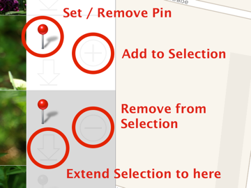
Pin Handling |
Next |
The pins on the map denote the geotags of your photos.
You move the map to find the location where a photo was taken, then you assign this location to the photo.
You can also use the map to see where you have taken photos. Select a pin on the map to show the photo in the photos list.
In Version 2.0 the pin buttons has been moved to the top:
![]()
From left to right it's:

![]()
As an alternative you can tap and hold anywhere on the map to set a location which is not under the crosshair cursor.
The area besides the thumbnails carries several distinct areas:
Please note: Tapping on the pin will set/remove a pin, but only if you are in Map mode!
![]()
![]()
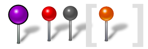
What do these pin colors mean?
There are two colors (red and purple) which can appear on a map and one (red) that appears on the photo list.
Version 2.0: grey and orange pins are no longer used

Red pins denote geotags for single photos. Tapping on a red pin shows the callout above the pin with some basic photo infos (or with the image title if one is given), and the photo is selected in the photos list on the left.

Purple pins denote multiple photos taken at the same location. Tapping a purple pin shows the number of photos behind the pin and selects all respective photos in the photos list.
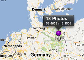
If you have zoomed out all the way, the pins are grouped together, so a single purple pin may denote all photos taken in a whole city, e.g.
© 2011-2014 by tin:b Software - Robert Fischer